VLBI - VERY LONG BASELINE INTERFEROMETRY
The technique of Very Long Baseline Interferometry (VLBI) is one of the Space-Geodetic techniques used to study the Earth dynamics and its orientation in space. The first VLBI observation was performed in 1967, more than 50 years ago. Initially conceived as a radio astronomy tool, its potential for geodetic applications was recognized early on. VLBI jointly with other space geodetic techniques provide the most accurate solutions for the terrestrial (TRF) and the celestial reference frames (CRF) and the Earth Orientation Parameters (EOP) for geodesy and astronomy, as well as for related sciences and practical applications. VLBI has special capabilities, which makes it the only modern technique for establishing and maintaining the celestial reference frame (CRF), Universal Time (UT), and movement of the Earth’s rotation axis in space, thus being the only technique that can provide alone the full TRF-EOP-CRF solution.
WORKING PRINCIPLE
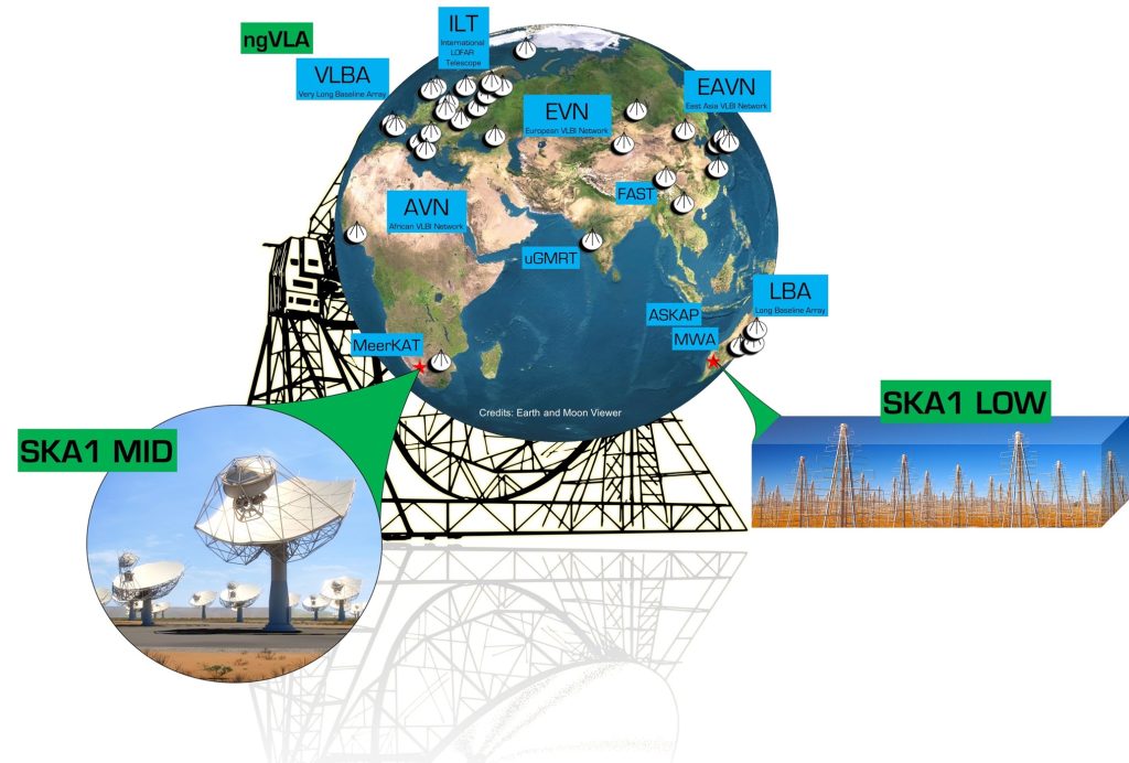
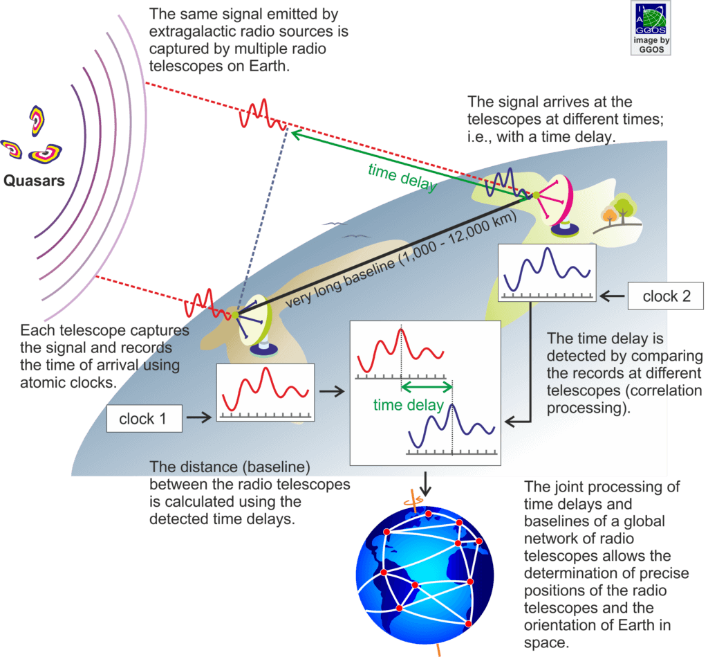
The VLBI technique is based on the observation of a celestial object simultaneously with a set of radio telescopes distributed around the globe, with the resulting effect of observing with the equivalent resolution of a telescope dish size of the maximum separation between the individual telescopes. This “artificial” radio telescope can reach the size of the Earth, or larger scales if there are space antennas included in the array. This huge telescope has a resolving power higher than the achieved with any other astronomical instrument (see Fig. 1). For this technique to work, the observatories need to have extremely accurate and stable equipment to establish a time reference – an Atomic Clock. Usually, for VLBI observatories these are Hydrogen Masers, and they are used to coherently condition, digitize and time-tag the signals received at each individual radio telescope. After this process, the signal is recorded at each station, using equipment like the Mark 6 recorders, and the data sent to the Correlation Centers. At this stage, the signals from each station are interfered constructively using powerful software of correlation, to obtain the time delay and corresponding distance (baseline) between radio telescopes (refer to Fig. 2).

The working principle of VLBI is in theory very simple: VLBI measures the difference in arrival times, at two (or more) radio telescopes of the signals emitted by distant radio sources by cross correlation. As shown in Fig. 2, the basic concept of VLBI consists of an incoming planar wave front that propagates from the radio source and arrives at two antennas, which point simultaneously at the same radio source separated by the baseline vector.
The time delay is measured by amplifying, down-converting in frequency, and digitally sampling, the radiation received from the radio source at each radio telescope site. Then, this digitalized signal is recorded and sent to a VLBI correlator for cross-correlation processing, where, finally, the time delay is computed.
Generally, the observed radio sources are distant and powerful quasars and radio galaxies that do not exhibit parallax or proper motions.

IVS NETWORK
In 1999, the International VLBI Service for Geodesy and Astrometry (IVS) was accepted as an official service for the International Association of Geodesy (IAG) and for the International Astronomical Union (IAU). Since then, the IVS has been responsible for coordinating world-wide VLBI observations and their analysis. IVS coordinates the VLBI observing programs, sets performance standards for VLBI stations, establishes conventions for VLBI data formats and data products, issues recommendations for VLBI data analysis software, and sets standards for documentation. It also coordinates its activities with the astronomical community due to the dual use of many VLBI facilities and technologies for both radio astronomy and geodesy/astrometry.
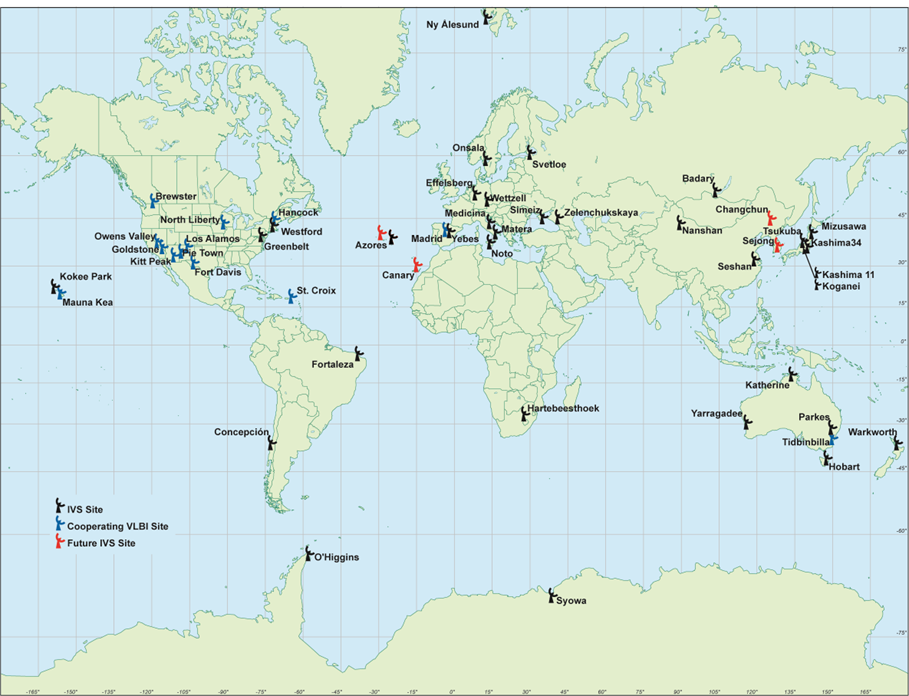
VLBI observations are sponsored by over 40 organizations located in 17 countries. Fig. 3 show the current IVS network. The RAEGE Stations are part of the IVS Network, participating in this global mission.

[Ref.] Image by ivscc.gsfc.nasa.gov
PRODUCTS
The IVS products can be defined in terms of their accuracy, reliability, frequency of observing sessions, temporal resolution of the estimated parameters, time delay from observing to final product, and frequency of solutions. VLBI data products currently available are:
- Reference Frames:
- Celestial Reference Frame (Fig. 4)
- Terrestrial Reference Frame (Fig. 5)
- Earth Orientation Parameters (Fig. 6)
- Troposphere and Other Ancillary Products (Fig. 7)

[Ref.] Image by ggos.org

[Ref.] Image by ggos.org

[Ref.] Image by ggos.org

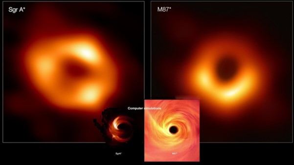
Since its invention, VLBI has been devoted to astronomical studies of relatively bright and compact radio sources, with sub-milliarcseconds angular resolutions. To obtain good fidelity in the images, VLBI uses the Aperture Synthesis technique that takes advantage of the rotation of the Earth during the observations to sample different frequencies in the Fourier space, that translate in better sampling in the target image plane. The culmination of the VLBI capability has been the recent obtention of the first images of the shadow of the event horizon of supermassive black holes in the active galaxy M87 and in the centre of our Galaxy, the Milky Way (Fig. 8).

For space geodesy, VLBI plays a unique role in the practical realization and maintenance of the International Celestial Reference Frame (ICRF) and contributes significantly to the International Terrestrial Reference Frame (ITRF), providing with unequalled accuracy the radio telescopes positions on the Earth. It is the only technique that provides the full set of Earth orientation parameters (movement of celestial and terrestrial poles and the measurement of the Earth instantaneous rotation), which are crucial for positioning and navigation on Earth and in space.
The International Celestial Reference Frame (ICRF) is currently based on nearly 40 years of data acquired by VLBI at the standard geodetic and astrometric radio frequencies (8.4 and 2.3 GHz), supplemented with data collected at higher radio frequencies (24 GHz and dual-frequency 32 and 8.4 GHz) over the past 15 years. The current realization of the frame, referred to as ICRF3, uses 303 “defining sources”, uniformly distributed on the sky, to define the axes of a quasi-inertial frame. Positions of stars in our galaxy are now tied to this reference frame, and this is the same reference frame used for measuring Earth orientation.
Geodetic VLBI also contributes to the realization of the International Terrestrial Reference Frame (ITRF) by measuring long intercontinental baselines within global networks. Current realisation of the terrestrial frame is referred to as ITRF2020. Compared to other space geodetic techniques using satellites, VLBI has the principal advantage that its realization of the ITRF scale only depends on the speed of light c, which is used to transform the delay observables into metric units.
FINAL REMARKS
Since 2005, the IVS has been working on a next generation VLBI system, known as VLBI Global Observing System (VGOS) to achieve accuracies of 1 mm in position and 0.1 mm/year in velocity on global scales, using continuous measurements to obtain uninterrupted time series of station positions and Earth orientation parameters, and a turnaround time from the observations to initial geodetic results of less than 24 h. In the near future, the IVS will change its EOP monitoring to VGOS with a considerable number of dedicated telescopes.
Some of the scientific results derived from VLBI include:
- Motion of the Earth’s tectonic plates;
- Regional deformation and local uplift or subsidence;
- Definition of the celestial reference frame;
- Variations in the Earth’s orientation and length of day;
- Maintenance of the terrestrial reference frame;
- Measurement of gravitational forces of the Sun and Moon on the Earth and the deep structure of the Earth;
- Improvement of atmospheric models.
[Ref.] Schuh, H., & Behrend, D. (2012). VLBI: A fascinating technique for geodesy and astrometry. Journal of geodynamics, 61, 68-80.
[Ref.] ITU-R, “Technical and operational characteristics of the existing and planned Geodetic Very Long Baseline Interferometry”, Report ITU-R RA.2507-0, 2022.
